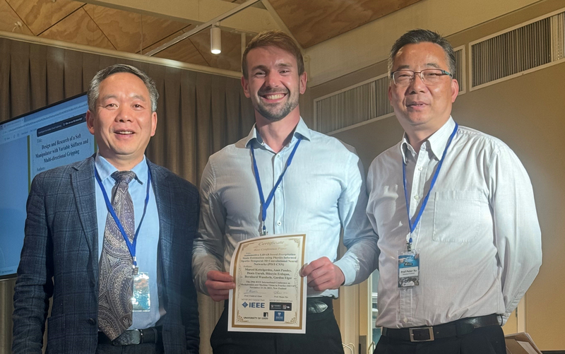
Research associate Marcel Kettelgerdes received the Best Paper Award at the 29th IEEE International Conference On Mechatronics and Machine Vision in Practice (M2VIP) in Queenstown, New Zealand for his publication on AI-based precipitation characterization based on degraded LiDAR (Light Detection and Ranging) sensor data.
The publication entitled "Automotive LiDAR based Precipitation State Estimation using Physics Informed Spatio-Temporal 3D Convolutional Neural Networks (PIST-CNN)" was developed as part of the "SAVeNoW" project (https://savenow.de/de/) funded by the Federal Ministry for Digital and Transport Affairs (BMDV) in cooperation with the Fraunhofer IVI Application Center in Ingolstadt and Conti Temic microelectronic GmbH. In order to be able to virtually test the environmental detection of autonomous vehicles, sensor models are required that can record the influence of rain and snow as well as ageing on the sensors. Marcel Kettelgerdes is devoting himself to this research in his doctorate supervised by Prof. Elger at the Institute for Innovative Mobility at THI. Accompanied by a student project with AI students at THI, a neural network architecture enriched with prior physical knowledge was developed, which estimates the current weather situation in the form of precipitation characteristics (particle size distribution, as well as precipitation type and rate) purely on the basis of weather-related measurement artifacts in the LiDAR data. For its training, an extensive database of high-resolution weather and LiDAR data was used, which was recorded as part of the project in order to investigate and model weather influences on safety-relevant automotive environment sensors.
LiDAR sensors are considered a key sensor for future automated driving functions due to their high spatial resolution and measurement accuracy. Continuous recording of local weather conditions while driving could be used to provide the driver or surrounding vehicles with qualified weather information without the need for additional sensors. Furthermore, the driving dynamics and corresponding safety-relevant driving functions could be flexibly adapted based on the type and intensity of precipitation and the resulting condition of the driving surface.
![[Translate to English:] Logo Akkreditierungsrat: Systemakkreditiert](/fileadmin/_processed_/2/8/csm_AR-Siegel_Systemakkreditierung_bc4ea3377d.webp)
![[Translate to English:] Logo IHK Ausbildungsbetrieb 2023](/fileadmin/_processed_/6/0/csm_IHK_Ausbildungsbetrieb_digital_2023_6850f47537.webp)