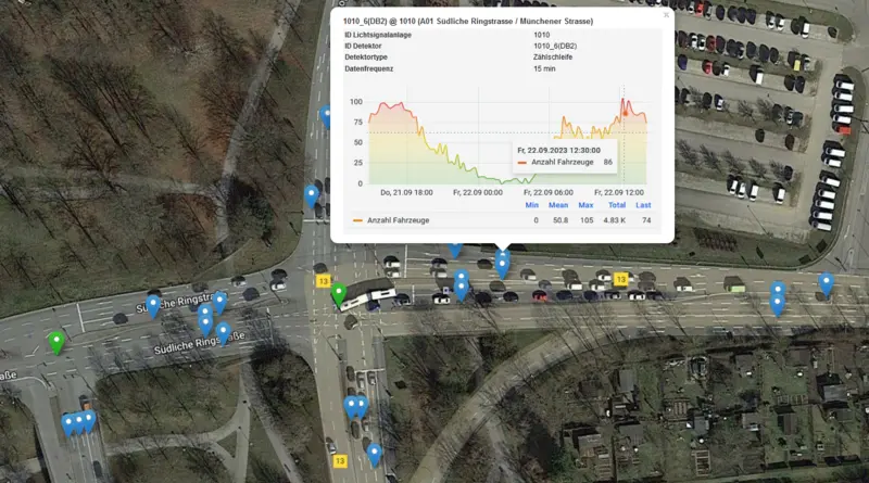
The collected data can be explored via a map application and a dashboard. Detailed documentation sheds light on the technical and content-related background. The main data source is the detector loops provided as Open Data (#odin) by the Office for Traffic Management and Geoinformation under the direction of Ulrich Schäpe, which are installed at all intersections with traffic lights. Each detector provides a count of the vehicles every 15 minutes so that the traffic volume for the most important intersections in Ingolstadt is available in 15-minute aggregates, accurate to the lane.
The second data source is a traffic camera installed at the Hindenburgstrasse/Ringlerstrasse junction. This records the paths (trajectories) of all road users, i.e. including the so-called "vulnerable road users" who travel on the cycle paths and footpaths and cannot be counted by the detector loops. Data protection is respected in that only the trajectories are stored and not the camera image. In addition, the camera is not able to recognize faces or number plates due to its installation.
Finally, the dashboard displays data from a high-resolution weather station that was installed at a Fraunhofer IVI laboratory near Ingolstadt Village as part of a sensor data validation project.
To make the data usable for the partners of the research project and the citizens of Ingolstadt, it is processed and made available on the internet via a standardized web interface, the OGC SensorThingsAPI. For this purpose, the Chair of Geoinformatics (TUM) has compiled an open-source Internet of Things (IoT) application stack in collaboration with e:fs TechHub GmbH. Currently, the data and services are being transferred to the cloud data platform SDK (Superb Data Kraken) for longer-term and stable availability.
The data obtained is used by THI scientists led by Professors Michael Botsch, Werner Huber, and Andreas Riener to calibrate the digital twin of Ingolstadt. This can be used to test different scenarios and make scientifically sound predictions. For example, it is tested whether changes in traffic such as automated vehicles or networked intersections increase road safety and achieve the desired effect at all. This paradigm also gave rise to a start-up at THI at the beginning of 2023, thireks GmbH.
![[Translate to English:] Logo Akkreditierungsrat: Systemakkreditiert](/fileadmin/_processed_/2/8/csm_AR-Siegel_Systemakkreditierung_bc4ea3377d.webp)

![[Translate to English:] Logo IHK Ausbildungsbetrieb 2023](/fileadmin/_processed_/6/0/csm_IHK_Ausbildungsbetrieb_digital_2023_6850f47537.webp)